Interest and excitement continues to grow around the potential uses for unmanned aerial systems (UAS) in agriculture. We see this interest being reflected in the increasing number of UAS-related exhibitors, sponsors and speakers participating in the annual InfoAg Conference. InfoAg, which is organized and hosted by the International Plant Nutrition Institute, is the premier event to discuss and view applied precision agriculture technology, and is attended by manufacturers, retailers, researchers (industry and university), advisers and consultants, producers and policy makers within the precision agriculture industry. The 2015 conference, which will be held in St. Louis, Missouri, July 28–30 (www.infoag.org), will feature exhibits for more than half-a-dozen UAS companies, flight demonstrations during the pre-conference tour, and speaker sessions on equipment, data management and regulations.
The excitement surrounding unmanned aerial systems is due not only to the opportunity for growers to rapidly collect large amounts of data, but also to the potential economic impact of the technology. In her 2014 presentation at InfoAg, Gretchen West, vice president of business development and regulatory affairs for DroneDeploy, reported that the global UAS market was $11.3 billion, and was expected to grow to $140 billion over the next 10 years. She also noted that the economic impact of U.S. airspace integration had the potential to grow to more than $82 billion between 2015 and 2025, with precision agriculture uses expected to total approximately 80 percent of the commercial market.
While FAA regulations have slowed the development of a commercial UAS industry in the USA, there has been some recent progress. Earlier this year, FAA released a Notice of Proposed Rulemaking (NPRM), detailing what commercial UAS regulations might look like for agriculture. While the NPRM is a step in a positive direction, several elements in the document including line-of-sight restrictions, allowable flight times, restrictions on number of people allowed in the flight area, and the limit of one drone per operator will continue to hinder growth of the U.S. commercial market.
Less-stringent airspace regulations in other countries have allowed more rapid commercialization of unmanned aerial systems, and precision ag service providers are reporting favorable results with UAS agricultural applications. At InfoAg 2014, Dale Cowan, senior agronomist at AGRIS Co-operative, provided a comprehensive overview of his UAS learning curve and experiences in Chatham, Ontario, Canada. For his purposes, Cowan chose a senseFly fixed-wing swinglet CAM, a ready-to-deploy mini-UAS ( Figure 1).
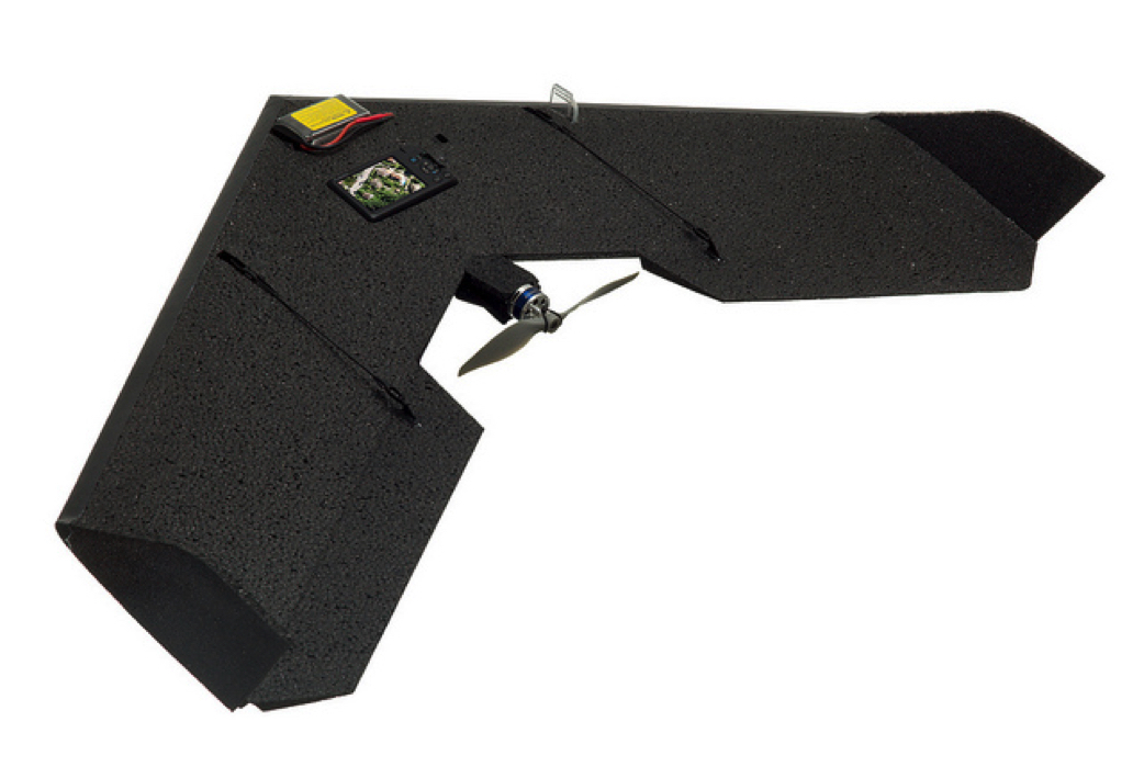
Figure 1. The senseFly swinglet CAM UAS.
Cowan mentioned several factors that need to go into the decision to buy a UAS, such as local support (training and technical support), fixed-wing versus rotary, coverage needs and durability. Durability and easily replaceable parts are not to be overlooked. According to Cowan, “It’s not how many times you fly, it’s how many times you land” that determines the life of a UAS. In his recent American Society of Agronomy webinar on unmanned aerial systems, Dr. Brian Arnall, precision ag specialist at Oklahoma State University, echoed this sentiment, stating, “They will crash. Period.”
Despite the inevitable rough landings, “flying was the easy part”, according to Cowan. The real challenge of a UAS, like for any other remote sensing approach, is in using the data to make a management decision that leads to better crop management. The first step in utilizing a UAS is image collection and processing. The swinglet CAM can cover a 130-acre field in 19 minutes, and takes a series of large (>350 MB) overlapping images that need to be mosaicked or stitched together ( Figure 2).
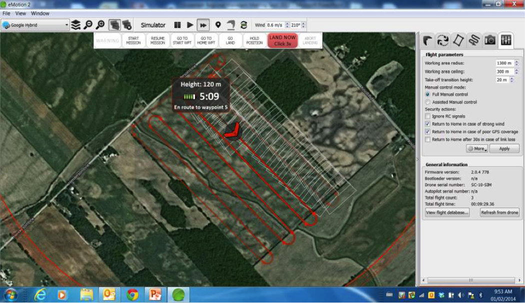
Figure 2. A ground-station view of the swinglet CAM flight path. Red line represents flight path, and each white square is an image — 70 percent fore-and-aft overlap.
Most unmanned aerial systems come with image processing software, but based on his commercial experience, Cowan suggested a higher-end software package for final analyses. He and his group are using a UAS for several applications including assessing winterkill in wheat, collecting NDVI measurements for N management in corn, and to establish management zones to guide soil testing, fertilizer management, seeding, scouting and yield evaluations. Another application that was profitable for their customers this past year was using the UAS to evaluate cover crop establishment. The UAS was used to collect color and infrared images of an established red clover stand in a 98-acre field ( Figure 3). The images were then used to develop management zones to guide soil nitrate sampling, rather than using the standard legume N credit, which assumes uniform coverage. The final product was a variable-rate N application map that resulted in fertilizer savings over both the standard, fixed-rate practice with no credit for the legume cover, and the standard, fixed-rate with N credit applied ( Table 1).
Although many of the early UAS applications have focused on crop scouting and N management, the potential for spatial management of other nutrients is great as well. Obviously, unmanned aerial systems can be used to quickly scout established crops for visible signs of nutrient deficiencies or stunted growth throughout the field multiple times during the season. This will be especially useful for micronutrients, which often show up in localized areas in the field due to subtle changes in pH, soil moisture and organic matter. Finally, unmanned aerial systems are already being used to quantify soil erosion. This imagery could be another layer in zone delineation for variable P management.
Despite all the possibilities for enhanced nutrient management, crop scouting, etc., it is important to remember that the UAS is just another tool in the precision ag toolbox. It is a remote sensing platform that helps us identify and define the need for spatial management of agronomic variability. There is no doubt that the potential benefit of unmanned aerial systems is huge. The opportunities for farmers to collect their own data, on-demand, have never been greater. But just as we’ve seen over the years with yield maps, aerial or satellite images, or crop sensors, remotely sensed data — in and of themselves — are useless until they are transformed into knowledge. As exciting as unmanned aerial systems are, we cannot get caught up in the hoopla and forget that a successful precision agriculture program must be built on the foundation of strong, science-based agronomy.
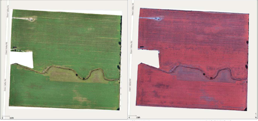
Figure 3. UAS color and infrared images of a red clover cover crop.
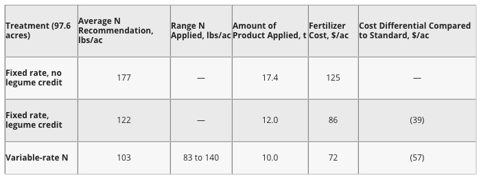
Table 1. Recommended N rates for corn following red clover cover crop. Variable N rates based on soil nitrate tests collected from management zones defined by using UAS images of cover crop establishment.
About the Author
Dr. Steve Phillips is a North American program director for the International Plant Nutrition Institute (IPNI). Dr. Phillips holds a B.S. degree from Cameron University in Lawton, Oklahoma, and M.S. and Ph.D. degrees from Oklahoma State University.
Dr. Phillips’ duties include development and dissemination of educational materials regarding the efficient and effective use of plant nutrients, with a focus on precision agriculture. Prior to joining IPNI in 2007, Dr. Phillips was an associate professor at Virginia Tech, where his program focused on variable-rate nutrient management and the development of N recommendation algorithms for sensor-based fertilization of wheat and corn in the mid-Atlantic region. Dr. Phillips has authored/coauthored 38 peer-reviewed journal articles, more than 150 extension and technical publications, and has participated in precision agriculture workshops and training events in several countries.
Dr. Phillips currently serves as chair of the IPNI international work group on precision agriculture, the annual InfoAg Conference, the A to Z track for practitioners at the International Conference on Precision Agriculture, and is an active member of ASA, SSSA, and ISPA.